Sunday, August 19, 2018

Elk and King Mountain run

The Elk King's Mountain race held in October has two courses, one a 25k up and over two mountain summits, the other is the 50k course which shares some of the 25k course minus the summits.

I decided it would be a great idea to spice things up and do both courses making a loop plus a long out and back including the near vertical assent/descent of the mountains.    It didn't quite go as planned but was still a reasonable 21 mile run with a LOT of elevation gain and loss.


Me at my starting point in the Elk Creek campsite. 


Tilllamook Forest has miles and miles of trails in an interconnected system.  There are lots of options for starting points and parking.   

Well sign posted too.  This is the start of the trail form the Campground. 

This is at the start of where it gets interesting, from this point it goes vertically directly up to 2700 feet.  No switchbacks here folks! 

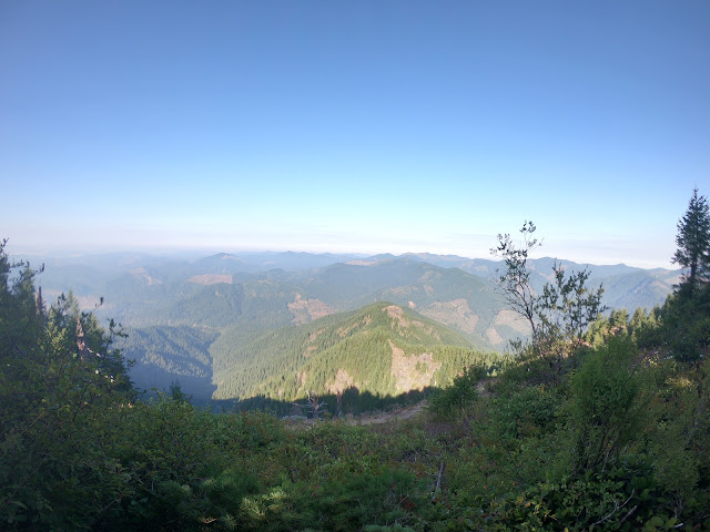
First opportunity for a view part way up towards Elk Mountain Summit. 

 At the summit.  Great clear views from here today.

Just to prove I was really there! 

This is looking at Kings Mountain from Elk Mountain.  I'm headed there next. 
The route is to the right and curves round to the summit.

At the junction of Elk, King and a third trail I have not yet been on. 

Yes, King Mountain summit is that way, not the little rock behind me. 

After a lot more vertical climbing up and down and more up's and through some nice fast run-able forest trail you get to the King Mountain summit.

I refilled my water bottles from the bigger bottle I carry in the back of the pack. Had a bite to eat on the move off the summit and headed 2200 feet down to the Wilson River trail.  I didn't take pictures on this section because its a bit "technical".  I'll leave the description at that, use your imagination! 

Quick picture from the summit before I headed off downwards. 

This is 2200 feet lower and on the junction with the Kings trail and the Wilson River trail.   The picture is looking up the Kings trail from the Wilson River trail.  I'm heading to the left of this sign now.

One of the few views on this seven-ish mile section of forest trail.  The trail goes through some nice valleys and dense forest.  Great running trail too with a mix of up and down to break things up. 

I stopped here by the edge of the river for some food.  Salty boiled potato and a big lump of cheese was delicious at this point.   

 Looking down the river from where I had a bite to eat just before Diamond Mill OHV staging area.  I'ts a really nice view here but completely spoiled by the awful noise and smell coming from the ATV's and dirt bikes being started up and apparently just revved to the limit for no reason.
The down side of the US is that the country promotes excess, greed, laziness and the desire to destroy every bit of the country with hydrocarbons and bullets.  Why cant people just go out and play on a mountain bike or walk, run, climb!  Everything in this damn country has to be powered by noise and oil pollution.  John Muir and Roosevelt would be absolutely disgusted by how the land they aimed to protect and keep pristine for the future generations has become a playground for noise and greed!
This is where my run outwards ended.  I followed the Wilson River Trail intending to get to the Forest Visitor Center about thee miles down the river, but after going round the edge of the OHV staging area the trail split up and the signs disappeared and I wasn't able to find the route that would take me down river.  I'm going to have to re-do this run but from the visitor center and see where it meets this location.  I had a map, but it wasn't detailed enough to see where the trail went. 
My intent was to do about 34 miles out and back, but it got cut short to 21 miles.
Still a really good run with a LOT of elevation.  

Elevation profile of the whole run.  You can see the first bit just goes vertical in a really short distance.  Then has another 1,000 foot-ish climb up then down to be repeated on the return journey.
I didn't go back over the mountain traverse, I might do that out and back another time for fun.

Map of where I went.

Total distance: 21.6 miles.
Elevation gain: Strava says 6,800 feet. 
Duration including some quick food and maintenance stops: 5hrs 43 mins.


Saturday, June 30, 2018

50k Run in the hills for last day of June

I decided on a long run for the last Saturday in June.  This will probably be my last long run (>20 miles) until after the Elk Kings 50k trail race in October and the 20 mile trail race in September at Mt St Helens.

Back County Rise:
https://www.daybreakracing.com/backcountry-rise-20m

Elk Kings:
https://gobeyondracing.com/races/elk-kings-25k-50k/50k/


I had a fairly high mileage month for June and done some back to back 50+ mile weeks, was feeling great and decided to top the month off with an epic run.  I've wanted to have a go at the 50k distance for a bit of time now and felt like it was the right time to have a crack at it.

Saturday morning was wet and a bit windy when I got up at 6:45 AM and didn't seem all that appealing in my semi awake foggy morning-head state.  Made my usual high octane oats and dried fruits breakfast (maybe a blog about that some time...) and had a cup of hot herbal tea.  By this time the rain had pretty much stopped and having woke up a bit more the run seemed like a better idea.

I got all my gear packed into the running pack and double checked everything and headed out the door feeling ready for a long run.  I had a goal of somewhere just under the six hour mark for this one.  The route is pretty steep a lot of the way and goes from sea level at home to about 2,800 feet up to Onion Peak.

Took it nice and slowly and even (hard as it is for me) took it easy and didn't charge up the hills which I usually love to do.

The route is an out and back with one additional side spur to add six miles bringing the intended total run distance to the 31.5 mile +- a bit route for today.

I didn't bother messing about with the camera too much because above 1800 feet ish was into the cloud base and visibility was down to just a few feet.  I did take a handful of pictures on the way down below the cloudbase.  They are posted below.

I drank and ate on the move, taking roughly 100 calories every 45 mins to an hour. Used a mix of raw honey and some oat based organic bars.  I also had some real food, an apple and a banana which I'm glad I took.

Was up at the base of the summit in about two hours, I didn't go all the way to the summit though because its inside a wildlife protected area.  This was at about the 12 mile mark.  Then after being thoroughly soaked by running inside a cloud and from the long wet grass and bushes I headed back along the ridge and then back up a side spur a few hundred feet higher.  Had a 5 minute food and maintenance stop there then plodded back down hill out of the clouds.


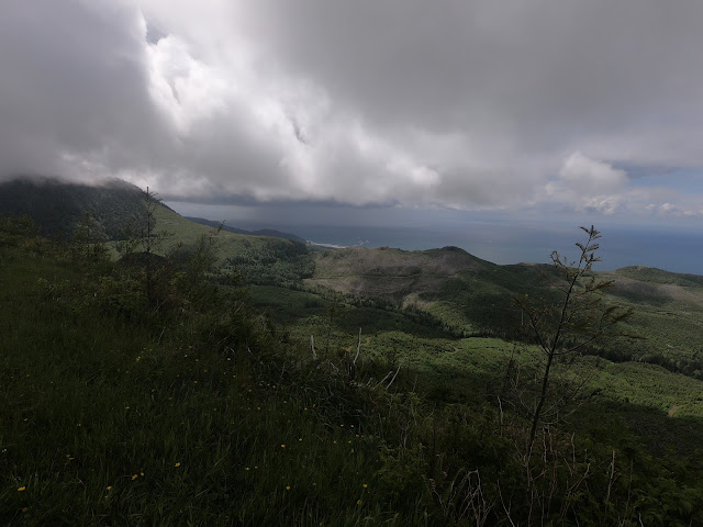
Looking back towards where I started from.  (out of site but down there somewhere in the distance)

The mountain top where I ran to is behind that gray cloud over the horizon.

One of me just to prove I really was there 😃  The summit is in the clouds.  This picture is at about 24 miles into the run.  I bumped into a couple out hiking with their dog just before this picture was taken and stopped for a few minutes for a conversation with them.

Elevation profile.  Total climb was 6,000 feet plus or minus a bit.  Distance somewhere between 32 and 34 miles.  The GPS on my watch was being a bit sporadic on the setting I was testing out so it wasn't totally accurate.  I looked at the topographic map route and the elevation seems about right though.


Overall a great run and I' happy with the time, distance and elevation gain/loss.


Saturday, June 9, 2018

Run to Ridge Spur with a view this time

Another run up to Ridge Spur, and since it was a clearer day and the cloudbase was high I was hoping to finally get a view from the top.
The last four attempts at this route failed to produce a view from the top due to the cloudbase dropping while I was going up.

The run started as usual from home and I made my way up through the Ecola Reserve park area and up into the wild bit of the hills.

Although the run to Ridge Spur isn't all that far at about 8.5 miles its a really hard one because of the elevation gain and a lot of it in a short distance.

Behind me is to the North with a view over the hill to Seaside.

Another view to the North.  This is only about 850 feet ASL at this point.  A long way to go yet.... and not many miles to do it in.

Finally a view from the top of Ridge Spur.  The top of Ridge Spur runs almost Northwest to Southeast, so the view isn't all that good to the North from up here.

Looking East-ish

West-ish to the small town of Archcape.

I took a video from the top, youtube has removed a lot of the quality after it uploaded, but here it is.


Normally when I run up here because its such a brutal route I just head for home, but I wanted to have a longer run time wise today so I explored a new road up in this area.

After running down a side spur road I came to this opening.  I could see a number of new roads waiting to be explored!

This is the road I ran down, there's a dead end just past where I'm standing.  It used to be a road but a landslide a really long time ago has closed it and there's new trees growing over it.


Strange rock formations exposed.

Along another side road off of where the pictures above were taken I ran down an interesting little set of hairpin bends than up onto a little hilltop.   The picture below is from the top of that little hill.  Looking Southwest.


The hairpins I ran down.

Looking Northwest towards Haystack Rock.

The run took me 3 hours 50 minutes including all the stops to enjoy the views.  It came to 21 mies with 4500 feet of elevation gain and loss.  My aim for this was to be moving for longer than usual on a harder route and I didnt care about pace or mileage.  A race I'm signed up for in October will probably take me about 6 hours to complete, so I need to do more days like this and even longer ones.

Elevation and mileage profile.


cameron franceymountain runningoregon cannon beachrunningwithcameronTrail Running


Sunday, April 29, 2018

Tillamook Run the Burn 20 Mile Race April 29th 2018

Back in January I decided to enter a couple of races for something to aim for.  First one of the year was this 20 mile trail race in the Tillamook Forest.  Since January I've built up (fairly quickly) to regular 50 + mile weeks building a good strong base.  Since I had never ran in a race before or even with other people I decided it was a good idea to start with a 20 mile trail race to get used to that before doing anything longer. Regular road racing is of no interest to me, trails are where I really enjoy running for hours on end with nature and in nature.  I have also signed up for a 50k trail race in October, and plan to do some other longer distances too.

I ran the course earlier in the year to get a feel for the route, and from that run I decided on a target of less than 3 hrs 58 minutes and with a stretch goal of 3 hrs 30, with the latter being optimistic.

I arrived at the trail at 7am and checked in and collected my race number, then headed back to the car to have my usual pre-long run breakfast of porridge with dried fruit and home made coconut milk  All organic of course.

Number 449


The race kicked off right on time, and somehow I ended up really close to the front and felt the pace was pretty easy going, so things were looking and feeling good.  I didn't want to end up too far back and get stuck and lose time, and at the same time didn't want to hold back too many others that were much faster if I was too far ahead, but I held my ground near the front end and cruised along for the start.

There was a group of photographers doing a great job over the course and I appeared in a few of the pictures.  Credit to them for the great job!  https://www.pursuitfilms.com/

Me heading down from the first aid station down a 6 mile stretch.
(photo credit: pursuitfilms.com)

I met and ran with some friendly people, had a great time and enjoyed the run.  I was feeling great for most of the race making sure not to get sucked up in a pack going faster than I should and suffering badly later in the race.

The route was all trail, with pretty much all of it run able with just a few really short sections that needed power hiked up.

This was in the last couple of miles.
(photo credit: pursuitfilms.com)

By mile 14 still with 2 and a bit miles of steep trail climbing still to go I decided to push the pace and get somewhere between my goal times.  The picture above was pretty close to the end when I was feeling a little wear from the last thee miles down steep hills over 1,000 feet and going pretty fast.  This is about mile 18.5 of 20.

Elevation profile

I finished strong feeling tired but good.  My time was 3:38:33, so only 8 and a half minutes off my stretch goal, so I am really happy with that result.
Looking a the results I came in 25th overall out of 155 finishers.  I had hopped to be somewhere middle of the pack and made it much closer to the front than I ever expected, so overall a great result.

Fill details of the results are here:   https://ultrasignup.com/results_event.aspx?did=50051 

The website for the race is here:  http://www.runtheburn.com/

Daybreak racing done a fantastic job hosting this event, and a huge thanks to them for all the hard work in organising this.


Thursday, April 12, 2018

April 12th Run up a new hill

April 12th run.

There's a lot of roads, trails and tracks to run on in the hills behind town, so this run was up a new hill that I've passed so many times but have always been out on longer run at the time so didn't go up it.
This time I took a run specifically to get to this hill top.

I was using my new trail shoes today for the first time,  Needed something with a little more foot protection but still minimalist as anything with a spongy mid sole just doesn't work for me.  The New Balance MT10 Trail shoe seems ok.  Not perfect but will be fine to keep in rotation when I want a little more sole protection from the hard rock surface on the forest roads.

Link to the shoe.
MT10v1 Trail


It was a dry day to start with, cool temperature and looked like it might rain at any time.

This is the North view from the top which at the highest point is 320 meters (1050 feet) That's Haystack Rock in the middle.


Looking South from the top.

Me at the top with the North view behind me.

Me again with the South behind me.  That cloud behind me opened up as I was running back down the hill.


Elevation profile and distance.
12 Miles.  The last part, the big hump in the middle of the elevation profile was really steep and most of it involved a bit of running then some power hiking then more running rather than running the whole thing.  Fast run down though.


Friday, March 30, 2018

March_30th_Ridge_Spur

This week my long run had to be on Friday after work.  Made it up to the top of ridge this time,  Still haven't managed to see anything from the top because although it was clear just before I got to the top the clouds came down and shrouded the top.  One of these days I'll get up there on a clear day.

This was my last run for March, and my total mileage for the month was 142 miles.


This is looking up towards where the next picture was taken from.  Its actually about 500 feet higher up but the picture doesn't show how steep this climb is.

Looking back from the same place as the picture above was taken from.


This is looking back at Cannon Beach from part way up before the clouds came in.  I ran all the way from near that little dot in the middle.

I zoomed into the middle part of this picture to show the rock.  The picture has flattened the scene so you don't get a good impression of how high up this actually is.  I think this part is at about 2,000 feet plus or minus a bit.

This is heading towards the last climb up to the top.  Probably another 400 or 500 feet further up to climb.  The clouds were starting to come in at this time so I knew after getting this far my view from the top was going to be blocked...AGAIN!

This is at the very top of Ridge Spur.  No view today!  2,500 feet above sea level.

Elevation profile.

Total mileage 17.36.
Good long and very hard run.